

.jpeg "The Plant")


 (1).gif "DMG")


 (2)1.jpg)
1.jpg "Kennedy Hire")


1.jpg "Last Call Spirits")


.jpg "Marler Probate Judge")

.jpg "Tri State Parking Lot")
.jpeg)


.jpg "Fun Zone")


Severe Weather Updated Timing and Threat Graphic
Matt BosterViewed: 1886
Posted by: Matt Boster
Date: Feb 07 2017 3:39 PM
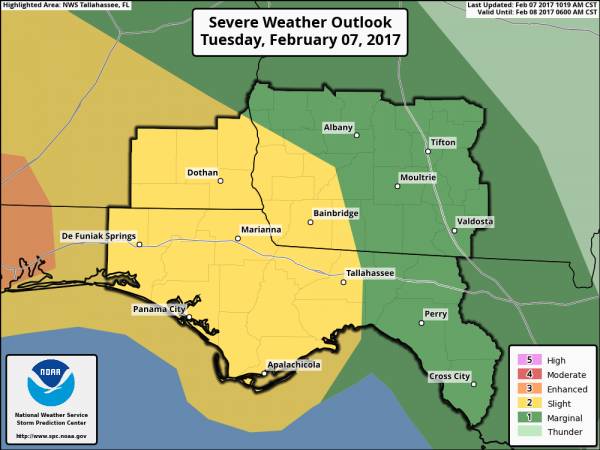
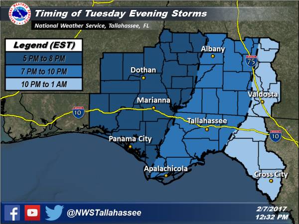
Give a quick update on the expected weather this afternoon through this evening. The Storm Prediction Center has extended the slight risk area farther eastward into portions of southwest Georgia and the Florida panhandle.
The main threats continue to be damaging wind gusts and large hail with impacts to trees and power lines. However, we cannot rule out an isolated tornado or two. It is possible that a tornado watch could be issued for portions of our area later this afternoon, most likely across the western half of the area.
The attached graphics show the updated risk area as well as our estimated timing for the greatest threat.

<- back

.jpg "Kennedy Hire")
.JPG "Wiregrass Electric")

 (2).jpg)
1.jpg "Marler for Probate Judge")


1.jpeg)


.jpg "Last Call Spirits")


.jpg "Harley Davidson")


