


1.jpg "Last Call Spirits")
 (2)1.jpg)
1.jpg "Kennedy Hire")


 (1).gif "DMG")
.jpeg "The Plant")


.jpg "Tri State Parking Lot")

.jpeg)
.jpg "Marler Probate Judge")


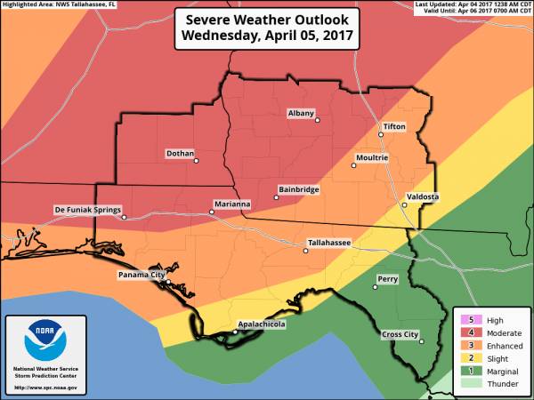
Round Two: Significant Severe Weather Event Expected Wednesday
Matt BosterViewed: 5870
Posted by: Matt Boster
Date: Apr 04 2017 8:29 AM
A significant severe weather event is expected to unfold across the Tri-State region on Wednesday. The Storm Prediction Center has portions of the area outlookedin a Moderate Riskat this time.
•Main hazards: All modes of severe weather will be possible.
•Tornadoes:Currently looks to be the greatest threat with this system, especially with any isolated storms. Some strong, long tracked tornadoes are not out of the question, especially in the Moderate Risk area.
•Damaging Wind:Destructive wind gusts as high as 70 mph will be possible.
•Large Hail:Hail potentially as large as golf ball size will be possible.
•High Surf:Surf of 5 to 6 feet expected along the Walton and Bay county coasts.
•Main impacts: Many trees and powerlines down, some structural damage.
•Timing: Though some thunderstorm development is possible late tonight, the main storms will develop after daybreak across southern Alabama. Current timing brings storms into western portions of the area by mid to late morning, with the main threat lasting into Wednesday night.

<- back

.jpg "Harley Davidson")


.jpg "Kennedy Hire")

 (2).jpg)


.JPG "Wiregrass Electric")
1.jpeg)


.jpg "Last Call Spirits")


1.jpg "Marler for Probate Judge")