


.jpeg)


1.jpg "Kennedy Hire")


 (2)1.jpg)


1.jpg "Last Call Spirits")


 (1).gif "DMG")
.jpg "Marler Probate Judge")


.jpeg "The Plant")


.jpg "Tri State Parking Lot")


.jpg "Fun Zone")


12:10PM Special Weather Statement issued.
Viewed: 2425
Posted by: Gary Matthew
Date: Apr 30 2024 12:08 PM
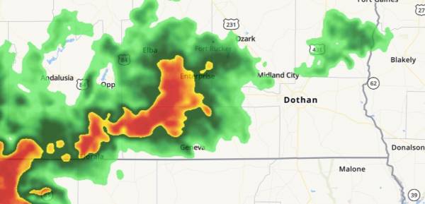
Active - Special Weather Statement issued April 30 at 12:06PM CDT by NWS Tallahassee FL
At 1206 PM CDT, Doppler radar was tracking a strong thunderstorm 8 miles northeast of Samson, or 10 miles north of Geneva, moving east at 25 mph. HAZARD...Wind gusts up to 40 mph and pea size hail. SOURCE...Radar indicated.
IMPACT...Gusty winds could knock down tree limbs and blow around unsecured objects. Minor hail damage to vegetation is possible. Locations impacted include... Daleville, Geneva, Enterprise, Dothan, Hartford, Taylor, Level Plains, Slocomb, Samson, Malvern, Clayhatchee, Esto, Coffee Springs, Noma, Black, Kellys Crossroads, Gerald, Central City, Logan Field Municipal A/P, and Cairns Aaf.
Sent from the Dothan Houston County AL EMA.

<- back


.jpg "Last Call Spirits")


.JPG "Wiregrass Electric")


1.jpg "Marler for Probate Judge")


.jpg "Harley Davidson")
.jpg "Kennedy Hire")


1.jpeg)


 (2).jpg)

