


 (2)1.jpg)


.jpg "Marler Probate Judge")


.jpeg)


1.jpg "Kennedy Hire")
 (1).gif "DMG")
1.jpg "Last Call Spirits")

.jpg "Tri State Parking Lot")


.jpeg "The Plant")


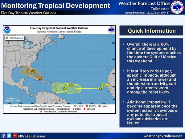
2:00 PM.. Update Tropical Weather Outlook from NHC
Matt BosterViewed: 4756
Posted by: Matt Boster
Date: Sep 11 2019 2:42 PM
- Although a depression could form before the system even reaches the Gulf, there is a 60% chance of development by the time the system reaches the eastern Gulf of Mexico this weekend.
- It is still too early to peg specific impacts, although an increase in shower and thunderstorm activity, surf, and rip currents seem among the most likely.
- Additional impacts will become apparent once the system actually develops or the hurricane center chooses to issue any potential tropical cyclone advisories.

<- back


.jpg "Kennedy Hire")
.jpg "Last Call Spirits")


.JPG "Wiregrass Electric")


.jpg "Harley Davidson")


1.jpeg)


 (2).jpg)

1.jpg "Marler for Probate Judge")

