


.jpeg)

.jpg "Marler Probate Judge")


1.jpg "Last Call Spirits")


1.jpg "Kennedy Hire")

.jpeg "The Plant")


.jpg "Tri State Parking Lot")

 (2)1.jpg)


 (1).gif "DMG")


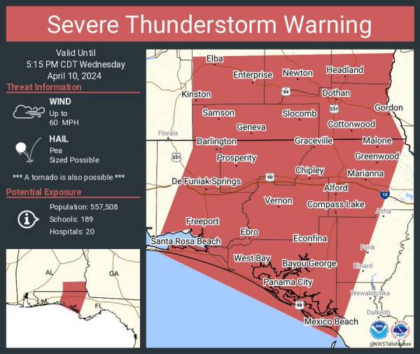
3:45pm Severe Thunderstorm Warning including Dothan AL, Panama City FL and Enterprise AL until 5:15 PM CDT
Rickey StokesViewed: 552
Posted by: RStokes
[email protected]
Date: Apr 10 2024 3:45 PM
Severe Thunderstorm Warning for... Dale County in southeastern Alabama... Southern Henry County in southeastern Alabama... Coffee County in southeastern Alabama... Geneva County in southeastern Alabama... Houston County in southeastern Alabama... Jackson County in the Panhandle of Florida... Northwestern Gulf County in the Panhandle of Florida... Bay County in the Panhandle of Florida... Western Calhoun County in the Panhandle of Florida... Walton County in the Panhandle of Florida... Holmes County in the Panhandle of Florida... Washington County in the Panhandle of Florida...
Until 615 PM EDT/515 PM CDT/. At 440 PM EDT/340 PM CDT/, severe thunderstorms were located along a line extending from 9 miles northeast of Samson to 10 miles southwest of Geneva to 7 miles southeast of De Funiak Springs to near Santa Rosa Beach, moving northeast at 35 mph.
60 mph wind gusts. SOURCE...Radar indicated. IMPACT...Expect damage to roofs, siding, and trees. Locations impacted include... Panama City, Lynn Haven, Panama City Beach, Callaway, Daleville, Elba, Cottonwood, Vernon, Bonifay, Geneva, Fort Novosel, Marianna, Headland, Dothan, Ozark, Santa Rosa Beach, De Funiak Springs, Enterprise, Chipley, and Graceville.
Remain alert for a possible tornado! Tornadoes can develop quickly from severe thunderstorms. If you spot a tornado go at once into the basement or small central room in a sturdy structure. For your protection move to an interior room on the lowest floor of a building. A Tornado Watch remains in effect until 900 PM EDT/800 PM CDT/ for southeastern Alabama...the Panhandle of Florida...and southwestern Georgia.

<- back


1.jpg "Marler for Probate Judge")
.jpg "Last Call Spirits")

.JPG "Wiregrass Electric")


 (2).jpg)


.jpg "Kennedy Hire")


1.jpeg)

.jpg "Harley Davidson")


