


.jpeg "The Plant")

 (1).gif "DMG")


.jpeg)
 (2)1.jpg)
.jpg "Marler Probate Judge")


1.jpg "Kennedy Hire")


1.jpg "Last Call Spirits")


.jpg "Tri State Parking Lot")


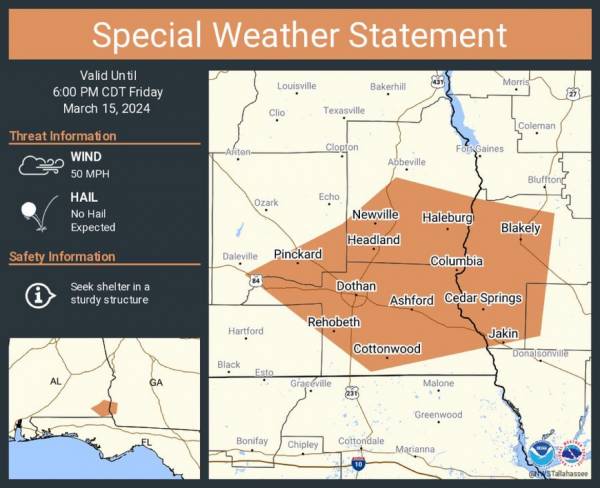
A special weather statement has been issued for Dothan AL, Blakely GA and Headland AL until 6:00 PM CDT
Rickey StokesViewed: 2041
Posted by: RStokes
[email protected]
Date: Mar 15 2024 5:18 PM
STRONG THUNDERSTORMS WILL IMPACT SOUTHEASTERN DALE...SOUTHERN HENRY...NORTHEASTERN GENEVA...HOUSTON...NORTHWESTERN MILLER AND EARLY COUNTIES THROUGH 700 PM EDT/600 PM CDT/... At 615 PM EDT/515 PM CDT/,
Doppler radar was tracking strong thunderstorms along a line extending from near Abbeville to near Kinsey to 7 miles north of Slocomb. Movement was southeast at 35 mph. The KOZR station in Ozark recently gusted to 36 mph. HAZARD...Wind gusts up to 50 mph. SOURCE...Radar indicated. IMPACT...Gusty winds could knock down tree limbs and blow around unsecured objects. Locations impacted include... Daleville, Abbeville, Cottonwood, Headland, Dothan, Blakely, Taylor, Midland City, Kinsey, Ashford, Cowarts, Newton, Webb, Columbia, Pinckard, Centerville, Malvern, Rehobeth, Grimes, and Avon.

<- back


.jpg "Harley Davidson")


1.jpg "Marler for Probate Judge")


 (2).jpg)


.jpg "Kennedy Hire")

.jpg "Last Call Spirits")

.JPG "Wiregrass Electric")


1.jpeg)


