


.jpg "Tri State Parking Lot")


.jpeg)

1.jpg "Kennedy Hire")


 (1).gif "DMG")

1.jpg "Last Call Spirits")


.jpeg "The Plant")


.jpg "Marler Probate Judge")
 (2)1.jpg)


National Weather Service Latest Update with Video from Webinar This Afternoon
Rickey StokesViewed: 1433
Posted by: RStokes
[email protected]
Date: Apr 09 2024 5:45 PM
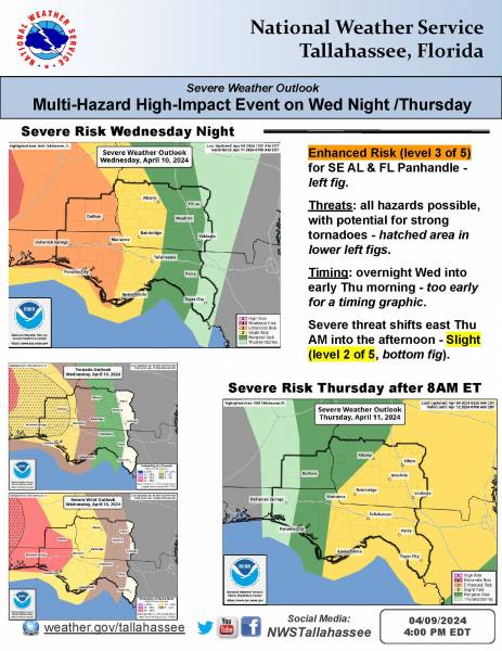
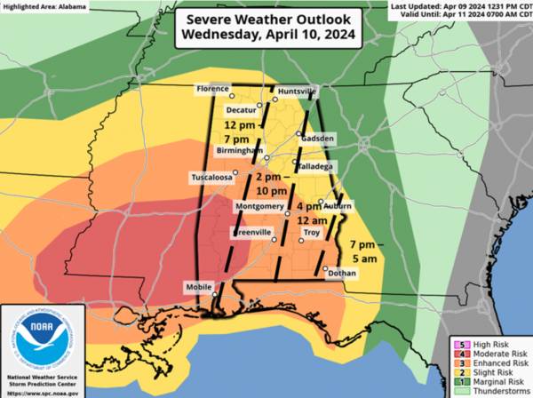
CLANTON – Tuesday 4:00 pm, April 9, 2024
A very potent upper level system will move across the southeastern US Wednesday into Thursday. The Storm Prediction Center (SPC) has upgraded much of western and southern Alabama to an Enhanced Risk, with a Moderate Risk in the southwestern sections.
It appears enough atmospheric instability (for severe thunderstorm growth) will be present by Wednesday afternoon in the western and southern sections of the state for a few supercells to develop ahead of clusters of strong to severe storms, then potentially consolidating into a line during the overnight hours. The highest threats of damaging winds (potentially exceeding 70 mph) and tornadoes (a couple EF2+) will be in both the Moderate and Enhanced Risk areas.
Damaging wind gusts and a couple of tornadoes are also possible in the Slight Risk area, but will be more isolated.
Having said all that, there still is the possibility that the forecast for instability is higher than will actually occur on Wednesday. Let’s hope so, as this would keep this from being a widespread severe weather event! Regardless, the system is so strong that at least some severe weather (and tornadoes) are expected.
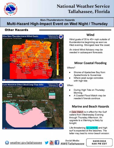
Outside of thunderstorm activity, winds will be on the increase statewide, sustained from 15-30 mph with gusts from 30-40 mph from Wednesday afternoon through early Thursday morning.
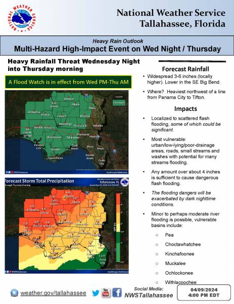
Widespread 2-4 inches of rain is forecast through Thursday afternoon and could be areas of 4-6+ inches. Exactly where the highest totals will occur is still uncertain. The NWS has issued a Flood Watch for all of central AL beginning at noon tomorrow.
Make sure you have at least two ways to receive weather warnings, that does NOT include an outdoor warning siren. Also, remember that except for the rare cases of extreme straight-line wind events, NWS Severe Thunderstorm Warnings WILL NOT trigger the Emergency Alert System (EAS) on your cell phone. Many people are surprised to wake up to damage occurring in the middle of an event without their cell phone sounding an alarm.

<- back


.jpg "Kennedy Hire")

.jpg "Harley Davidson")


.jpg "Last Call Spirits")


1.jpeg)


 (2).jpg)

1.jpg "Marler for Probate Judge")


.JPG "Wiregrass Electric")


