


1.jpg "Last Call Spirits")


.jpeg "The Plant")

 (2)1.jpg)


.jpg "Marler Probate Judge")


.jpg "Tri State Parking Lot")


.jpeg)


 (1).gif "DMG")


1.jpg "Kennedy Hire")


Severe Weather and Heavy Rainfall Today through Sunday
Matt BosterViewed: 1381
Posted by: Matt Boster
Date: Apr 08 2021 8:26 AM
Bottom Line:
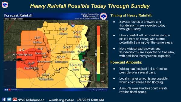
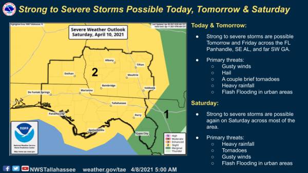
Several rounds of severe weather and heavy rainfall will be possible today through Sunday as a cold front stall out over the area. Primary threats today will be gusty winds, hail, and perhaps a brief tornado. Primary threats tomorrow are forecast to be heavy rainfall, gusty winds, small hail, and another brief tornado threat. Primary threats on Saturday are forecast to be heavy rainfall, tornadoes, and gusty winds. On Sunday another front finally clears the unsettled weather out from west to east.
Overview:
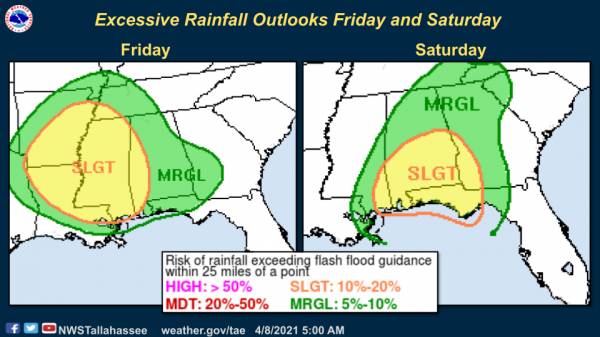
Showers and thunderstorms will begin to move in from the west today as a cold front approaches the area. This front will stall out over the area tonight and will eventually become the focus for another round of showers and thunderstorms tomorrow. Both today and tomorrow have a marginal risk for severe weather. Tomorrow, pockets of heavy rainfall will also be possible, and WPC has placed much of the area at a marginal risk for excessive rainfall.
On Saturday, a second, stronger frontal system approaches bringing more widespread showers and thunderstorms to the area. Severe weather will be possible again on Saturday with most of the area at a slight risk from SPC. With increasing wind shear, tornadoes and heavy rainfall will be the primary hazards on Saturday, and any heavy rainfall received on Friday could lead to higher sensitivity to rainfall on Saturday.
Widespread rainfall totals for the multi-day event are forecast in the 2 to 5-inch range, with isolated higher amounts possible. Amounts over 4 inches have the potential to cause riverine flooding issues, and flash flooding will be a concern especially on Saturday.

<- back


 (2).jpg)
.JPG "Wiregrass Electric")


.jpg "Last Call Spirits")

1.jpeg)


.jpg "Harley Davidson")
1.jpg "Marler for Probate Judge")


.jpg "Kennedy Hire")


