


.jpeg)


 (2)1.jpg)


.jpeg "The Plant")


 (1).gif "DMG")


1.jpg "Last Call Spirits")


.jpg "Marler Probate Judge")
1.jpg "Kennedy Hire")


.jpg "Tri State Parking Lot")


The National Weather Service: Severe Weather Risk and Ongoing Dangerous Heat Today
Viewed: 2121
Posted by: Staff
Date: Jun 14 2022 10:09 AM
The main concerns today revolve around dangerous, advisory-level heat and the potential for severe weather this afternoon and evening. In particular, there is some uncertainty regarding the severe weather potential, with two possible scenarios outlined below.
Overview:
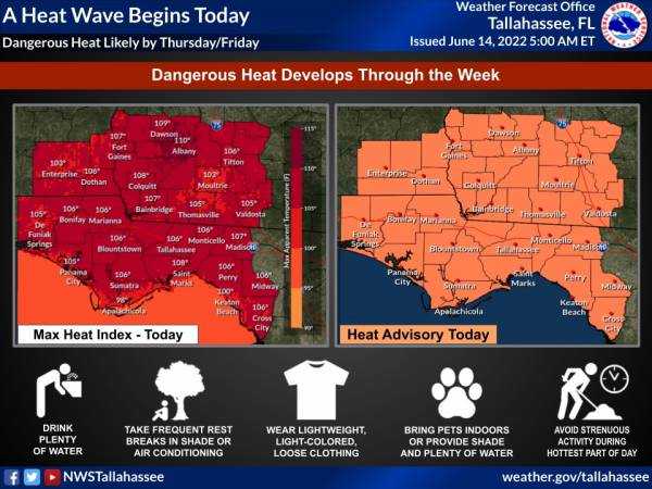
High temperatures today in the middle to upper 90s coupled with the humidity will result in Apparent Temperatures/Heat Index values between 105 and 110 degrees. This will be on average a few degrees higher than yesterday. Going forward, Apparent Temperatures/Heat Index values are expected to increase further to around 110 degrees from Wednesday into this weekend. The prolonged period of early-season heat will become increasingly dangerous to vulnerable populations and those not acclimated to the heat.
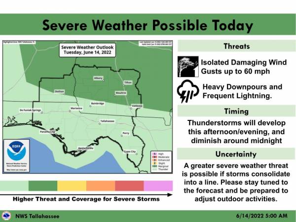
Thunderstorms are expected to develop this afternoon and evening and diminish around Midnight. There is some uncertainty regarding severe weather potential. As a result, there are two possible severe weather scenarios.
The first and most likely scenario is for storms to develop this afternoon and evening. These storms will be capable of isolated damaging wind gusts and frequent lightning, especially in Southeast Alabama and Southwest Georgia, where the Storm Prediction Center has outlooked a Marginal Risk of severe weather.
The second scenario is less likely (has a lower probability of occuring), but would result in a greater impact. In this scenario, storms consolidate into a squall line over the Southern Appalchians and move Southwestward into the Tri-State area late this afternoon into early tonight. While this has a lower potential of occuring, it would have a greater impact in terms of damaging wind gusts, possibly requiring both an expansion and upgrade to the severe weather risk.

<- back


.JPG "Wiregrass Electric")


1.jpeg)


.jpg "Kennedy Hire")


 (2).jpg)

.jpg "Harley Davidson")


.jpg "Last Call Spirits")


1.jpg "Marler for Probate Judge")

