


.jpg "Marler Probate Judge")

.jpeg)

 (2)1.jpg)


1.jpg "Last Call Spirits")
1.jpg "Kennedy Hire")


.jpg "Tri State Parking Lot")
.jpeg "The Plant")


 (1).gif "DMG")


Weather Update from the National Weather Service
Viewed: 1788
Posted by: Staff
Date: Apr 08 2024 7:59 AM
Bottom Line:
No watches or warnings are in effect at this time.
A multi-hazard high-impact weather event is expected on Wednesday Night and Thursday. Hazards to plan for will include:
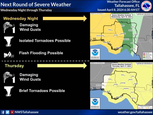
- Slight Risk (Level 2 of 5) of Severe Thunderstorms
- Damaging Wind Gusts
- Isolated Tornadoes Possible
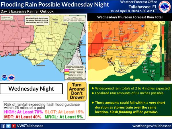
- Moderate Risk (Level 3 of 4) of Excessive Rainfall. Flash flooding and minor river flooding possible.
- Strong winds outside of thunderstorms.
- Coastal and Marine Hazards
- Minor coastal flooding possible from Apalachicola to Suwannee
- High Surf Likely. Life-threatening Rip Currents Expected.
- Gales Possible over the Gulf waters.
Overview:
A vigorous cold front on Thursday will be preceded by high-impact weather from Wednesday PM until the front passes on Thursday.
Isolated severe thunderstorms are possible. This will be a very-high shear / low instability setup, which typically favors damaging wind gusts and a few weak tornadoes. Against the backdrop of very strong wind shear, if even a little more instability develops than forecast, then a greater risk would be warranted.
Thunderstorms could repeatedly train over the same places, leading to excessive rainfall, flash flooding, and minor river flooding. The more favored areas are over southeast Alabama, Southwest Georgia, and the Florida Panhandle. Widespread rain amounts of 2 to 4 inches are expected, and localized amounts of 6+ inches are possible.
Strong south winds in advance of the front will bring coastal and marine hazards, including possible gales over the Gulf, high surf and life-threatening rip currents at the beaches, and minor coastal flooding during high tides.
Over land, a Wind Advisory may eventually be needed in places.

<- back


1.jpg "Marler for Probate Judge")


.JPG "Wiregrass Electric")
.jpg "Last Call Spirits")


1.jpeg)


.jpg "Harley Davidson")


 (2).jpg)


.jpg "Kennedy Hire")

