


.jpg "Marler Probate Judge")


.jpeg)


 (2)1.jpg)
1.jpg "Kennedy Hire")


.jpg "Tri State Parking Lot")


 (1).gif "DMG")


.jpeg "The Plant")


1.jpg "Last Call Spirits")


Isolated Severe Weather Today and Excessive Rainfall through Wednesday Night
Matthew BosterViewed: 1033
Posted by: Matthew Boster
Date: Mar 26 2024 7:35 AM
Changes Since Last Briefing:
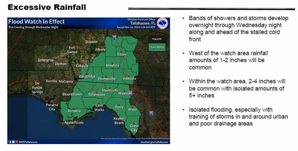
Issued a flood watch beginning this evening through Wednesday night from Gulf County northeastward to Worth County and areas eastward. Rainfall amounts with the system continued the trend upward, especially in the flood watch area where 2-4 inches are possible with isolated areas of 5+ inches.
Bottom Line:
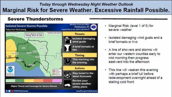
Strong to isolated severe thunderstorms are possible today along with heavy rainfall through Wednesday night.
Overview:
A line of showers and thunderstorms associated with a cold front will enter southeast Alabama and the western Florida panhandle this morning then slowly progress east through the day. The main threats with this line will be strong to damaging wind gusts and perhaps a brief tornado. The Storm Prediction Center continues a Marginal Risk (1/5) for severe weather in our southeast Alabama and majority of our Florida counties and adjacent southwest Georgia counties. The line will gradually weaken into the late afternoon and evening hours. The cold front will slow down and briefly stall tonight into Wednesday before pushing further east and away from the area Thursday.
For rainfall - the line of showers and storms will progress into the central portions of our service area while weakening later today. As the cold front stalls and brief lull in heavy rainfall, showers and storms redevelop overnight along and ahead of the front. Training of convection will lead to bands of heavy rainfall through Wednesday night before ultimately the system moves east Thursday morning. West of the flood watch area, 1-2 inches of rainfall will be common.. Within the flood watch, 2-4 inches with isolated amounts of 5+ are possible. WPC continues the Slight Rick (2/4) for excessive rainfall Wednesday and Wednesday night.
Concerning coastal and marine impacts - The gale warning for waters west of Apalachicola will expire at 7 AM CT and be replaced by a small craft advisory as winds and seas will remain elevated through this evening. Dangerous and life threatening rip currents will exist through much of this week along all our local beaches. High surf with heights of 6-7 feet is expected through this evening along the Walton and Bay county coasts.
Lastly, breezy conditions will exist today with southeast winds of 15-20 mph with gusts to 30 mph.

<- back


.jpg "Kennedy Hire")


.jpg "Harley Davidson")


1.jpeg)


1.jpg "Marler for Probate Judge")


.JPG "Wiregrass Electric")


.jpg "Last Call Spirits")

 (2).jpg)
