


1.jpg "Last Call Spirits")


 (2)1.jpg)
.jpg "Marler Probate Judge")


.jpeg)

.jpg "Tri State Parking Lot")
1.jpg "Kennedy Hire")


.jpeg "The Plant")


 (1).gif "DMG")


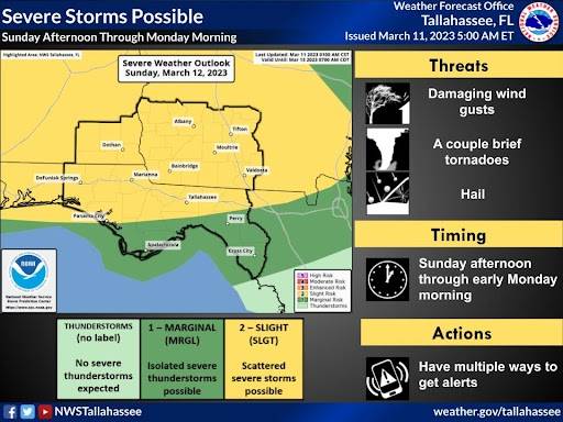
NWS Updated Weather for Sunday and Monday
Viewed: 5803
Posted by: JRTyson
[email protected]
Date: Mar 11 2023 9:23 AM
Severe weather is possible Sunday afternoon through early Monday morning with damaging winds, hail near golf ball size, a few tornadoes, and isolated flooding all possible.
A cold front is forecast to push slowly southward through the region Sunday afternoon through Monday morning with showers and thunderstorms along and ahead of it. Some of these storms could be strong to severe, with damaging winds, hail near golf ball size, a few tornadoes, and isolated flooding possible. SPC has outlooked most of the area in a Slight Risk (level 2/5) for severe weather Sunday and Sunday night. Most of Southeast Alabama and Southwest Georgia are also in a Marginal Risk for Excessive Rainfall.
The best chance for severe weather currently is Sunday afternoon into Sunday evening, but the threat may linger through the overnight hours and diminish into Monday morning.

<- back

.jpg "Kennedy Hire")


1.jpeg)


.jpg "Last Call Spirits")


.JPG "Wiregrass Electric")

.jpg "Harley Davidson")
 (2).jpg)


1.jpg "Marler for Probate Judge")


