


 (2)1.jpg)


.jpg "Marler Probate Judge")


.jpg "Tri State Parking Lot")


 (1).gif "DMG")

1.jpg "Last Call Spirits")


.jpeg "The Plant")


1.jpg "Kennedy Hire")

.jpeg)


Severe Thunderstorms Possible On Monday
Viewed: 3916
Posted by: JRTyson
[email protected]
Date: Mar 26 2023 6:04 PM
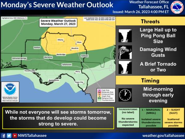
There is a Slight Risk of severe thunderstorms (level 2 of 5) across southwest Georgia and a Marginal Risk (level 1 of 5) across the Florida Panhandle and Big Bend and southeast Alabama. Large hail and damaging winds are the primary threats, but a brief tornado or two cannot be ruled out.
A stationary front currently over central Alabama and central Georgia will move southward into southern Alabama and southern Georgia. A broken line of thunderstorms will move into southeast Alabama and southwest Georgia around mid-morning, moving slowly southeastward through the day. The individual cells in the line will pose a large hail and damaging wind risk. While the tornado risk is a bit lower, it is non-zero, and a brief tornado or two cannot be ruled out. The storms move toward the I-10 corridor by late afternoon or early evening before diminishing in intensity.
Looking ahead to Tuesday, the cold front will sink into the Florida counties. While there is not a risk currently outlined, it is possible we may see a severe risk introduced for parts of the area Tuesday.
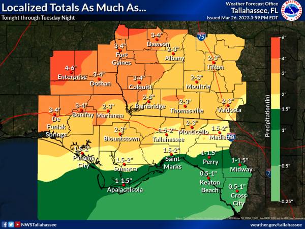
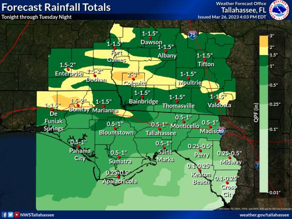
Widespread rainfall totals through Tuesday night will be around 1 to 2 inches north of Interstate 10 with less than an inch farther south. However, should storms begin training, localized totals of 3 to 5 inches are not out of the question. Totals this high could result in a localized flash flood risk. There is a Marginal Risk of excessive rainfall both Monday and Tuesday across the area.

<- back


1.jpg "Marler for Probate Judge")


.jpg "Harley Davidson")


 (2).jpg)


.jpg "Last Call Spirits")
.jpg "Kennedy Hire")


1.jpeg)


.JPG "Wiregrass Electric")


