

 (2)1.jpg)


.jpg "Tri State Parking Lot")


1.jpg "Kennedy Hire")
.jpeg)


.jpeg "The Plant")
.jpg "Marler Probate Judge")


1.jpg "Last Call Spirits")


 (1).gif "DMG")


Significant Weather Statement Sunday Morning 10:00am
Viewed: 588
Posted by: JRTyson
[email protected]
Date: Mar 12 2023 10:28 AM
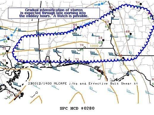
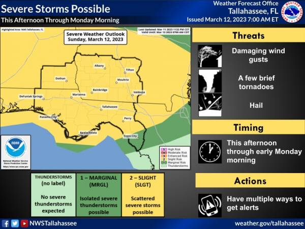
Strong thunderstorms will impact portions of Dale, western Henry,Coffee, Geneva, western Houston, Walton, Holmes and central Washington Counties through 1100 AM CDT... At 1017 AM CDT, Doppler radar was tracking strong thunderstorms along a line extending from near New Brockton to 6 miles southeast of Crestview. Movement was east at 55 mph. HAZARD...Winds in excess of 40 mph and pea size hail. SOURCE...Radar indicated. IMPACT...Gusty winds could knock down tree limbs and blow around unsecured objects. Minor damage to outdoor objects is possible. Locations impacted include... Daleville, Elba, Abbeville, Vernon, Bonifay, Geneva, Headland, Dothan, Fort Rucker, Ozark, De Funiak Springs, Enterprise, Hartford, Taylor, Midland City, Kinsey, Level Plains, Slocomb, Samson and Newton. PRECAUTIONARY/PREPAREDNESS ACTIONS... If outdoors, consider seeking shelter inside a building. These storms may intensify, so be certain to monitor local radio stations and available television stations for additional information and possible warnings from the National Weather Service. && MAX HAIL SIZE...0.25 IN; MAX WIND GUST...40 MPH


<- back


.jpg "Harley Davidson")


.jpg "Kennedy Hire")


1.jpg "Marler for Probate Judge")


 (2).jpg)


1.jpeg)


.JPG "Wiregrass Electric")

.jpg "Last Call Spirits")