


.jpeg "The Plant")


 (2)1.jpg)

.jpeg)

 (1).gif "DMG")


1.jpg "Last Call Spirits")


1.jpg "Kennedy Hire")


.jpg "Tri State Parking Lot")


.jpg "Marler Probate Judge")


Weather Outlook for Friday thru Monday
Viewed: 3416
Posted by: JRTyson
[email protected]
Date: Mar 10 2023 12:19 PM
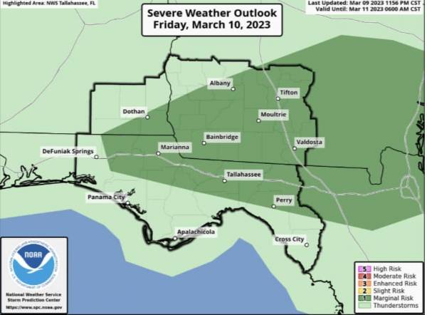
There is a Marginal (level 1/5) risk for severe weather this afternoon and evening across much of the area. Gusty winds and hail are the primary concerns.
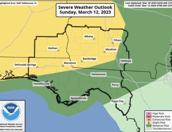
There is also a Slight (level 2/5) risk for severe weather on Sunday across the FL Panhandle, SE Alabama, and SW GA. Gusty winds, hail, and a brief tornado are the primary concerns.
Overview:
Today: A cold front is forecast to push through the area later today with showers and storms along and ahead of it. Gusty winds and hail will be possible with the stronger storms, and the best window for severe weather exists this afternoon and evening. A Marginal Risk has been issued for our area today.
Sunday: Another, stronger cold front is forecast to push through the area Sunday into Monday. Strong to severe thunderstorms will be possible with this front as well, with gusty winds, hail, and brief tornadoes possible. The timing of this second system seems less certain, but for now the best chance for severe weather seems to be Sunday afternoon into Sunday night. Much of the area is currently in a Slight Risk for severe weather, with the Marginal Risk area extending further eastward.

<- back


1.jpg "Marler for Probate Judge")


 (2).jpg)

.JPG "Wiregrass Electric")


1.jpeg)


.jpg "Last Call Spirits")


.jpg "Harley Davidson")


.jpg "Kennedy Hire")

